Monday, March 11, 2013

Jelajah ke Co. Kerry (Ring of Kerry) Part III

Makluman: Article ni adalah ditulis berdasarkan pengalaman sendiri. Info tambahan adalah hasil dari kerja-kerja mengGoogle

Part 3 of 3


Portmagee

We were driving towards west. Portmagee is our target. And to be specific, we were looking for Kerry Cliffs Viewing Point. Masa ni Google Maps was not that popular apatah lagi nak pre-download the map, so we depended on Garmin. But to find the Viewing Point using Garmin was not easy. Apparently I saved wrong POI coordinate so we ended at dead end. Banyak kali sesat. 


Posing sesat


Kerry Cliffs Viewing Point

Akhirnya pencarian membuahkan hasil. It was really worth it. Viewing Point ni dekat ngan 'Kampung' nama Doora Cross. We parked the car, the counter was gonna close in 1 more hour. It was almost 6pm. By looking at satellite view below, I can clearly see the cliffs by the sea. And when I browse around the Google Map, apparently there are more cliffs around Portmagee.


Kitorang sampai pon dah lewat. Masa tu tak nampak tourists lain dah. Only us. Luckily the counter was still open. Entrance fee pon tak ingat berapa, kalo tak silap €4 sorang kot. The car parking was free. Then we have to walk around 10 minutes to get to the Viewing Point. Bukan jalan premix, but earth road. So bergoncang2 stroller Affan kena tolak. The official link can be found here

Ana at the counter entrance. Credit: fb Ana Nae

The best part, takyah jalan jauh macam Cliffs of Moher. Tak perlu panjat tinggi2. The viewing point is easy to reach especially those with toddler like us. And it promised beautiful cliffs scenery


Subhanallah

Credit to Adi yg sanggup panjat tinggi to shoot from this nice angle

Skodeng mende tu?


That's Skellig Michael. The famous island in Ireland, inscribed on UNESCO list


As always, with the guys

We... are... family...

Lama gak lepak kat sini. Bergambar tak hingat punya. Si adi n nazri lak masing2 ada DSLR, so byk la composition dan ilmu teknik photo shooting yg nk apply. Si husband tonggeng sana, tonggeng sini amik gambar. Yg wife masing2, senyum sana, senyum sini. hihi. Rasanya mat saleh jaga kaunter tu dah sangap tunggu kitorang setel. We were the last tourists.

Dah nk dekat maghrib

Cer teka? Nape Adi jadi lagu ni hehe

Our last group photo before we head back to Limerick

Slan Kerry... End of Part III

Saturday, March 2, 2013

Jelajah ke Co. Kerry (Ring of Kerry) Part II

Makluman: Article ni adalah ditulis berdasarkan pengalaman sendiri. Info tambahan adalah hasil dari kerja-kerja mengGoogle

Part 2 of 3

Gearhameen

From Gallavally, we drove for few hours, and we stumbled upon this point, the view is magnificent. Kalo tak silap, ni dekat2 Gearhameen, just before we reach Gap of Dunloe (GoD). The hills, the green, the curvy road... rasa mcm dlm movie pon ada. Ala2 citer Dragon Heart. The weather was around 11°C. Sebijik rasa mcm kat oversea (bak kata Aida). 

Gearhameen


Gap of Dunloe

Sedar tak sedar, we have already entered GoD. Kiri kanan penuh bukit berbatu. Mat saleh yg berbasikal, hiking pon ada. Kereta kuda padi (pony) pon banyak. Makin susah kitorang nk cilok sbb jalan sempit. Nak selisih kereta pon kena agak2. Coverage tepon mmg takde la. Kalo ada walkie talkie cara gak. 


Gap of Dunloe (atau Irish sebut Dún Lóich) ni adalah satu route terletak di celah gunung ganang iaitu Macgillycuddy's Reeks (barat) dan Purple Mountain (timur). Jaraknya lebih kurang 11km dari utara ke selatan. Dalam GoD ni ada 5 tasik di mana semua tasik ni bersambung ngan River Loe


Try test echo gunung

Scenery GoD ni buat aku rasa mcm kat studio Hollywood. Macam citer Harry Potter pon ada, suasana sunyi je. Batu batan warna chrome berkilat2. Takde dengar bunyi kete ke, bunyi binatang ke. Sungai masa tu cetek, so tak dengar bunyi arus sungai. Kalo bercakap, suara akan bergema-gema. Aku penah try jerit, bunyi echo yg panjang mendayu2. Risau gak kang runtuh gunung2 tu. Alhamdulillah masa kitorang sampai, takde tourist lain kat situ. Kejap2 baru ada kereta kuda pony lalu

 Wishing Bridge

Spot paling cantik is at this beautiful old arch bridge yang dipanggil Wishing Bridge. Kononnya sapa yg make wish masa atas bridge tu, akan come true. hehe. We all lepak kat spot ni agak lama, posing sana sini. Shooting sini sana. Nazri siap panjat bukit nk bergambor punya pasal

 Posing mencangkung

The guys

 Bergambar ngan Wishing Bridge. credit: fb Ana Nae

Nazri and Ana bergambar with ruined house. Credit: fb Ana Nae

Between two rocks. credit: fb Ana Nae

Our journey to GoD ended at this small town called Kate Kearney's Cottage. Masa ni nappy Affan dah berat gila. Aku lak lupa nk bawak nappy extra masa kluar rumah tadi. Tuhan je la tau betapa serabut nya keadaan. Dengan tebal muka, aku mintak nappy sekeping dari mat salleh lain with family. Diorang berbesar hati sedekah sehelai hehe. Baru la si mama boleh senyum bergambar. Kalo tak sebelum tu muka masam je :P

 RnR di Kate Kearney's Cottage

Our next destination is Portmagee. We heard that it has the best Kerry Cliffs viewing spot. We drove for few more hours towards West. Driving by the coast is undescribable. The view is breathtaking


Budak kaca mata

We drove across some small towns like Killorglin and Glenbeigh. Berenti jap bila jumpa ancient buildings macam Cathedral, Castles etc. Nama bangunan kitorang tak amik port. Nampak lawa je, stop dan posing :D


 Castle

Cathedral

Travelers with 'kapcai'

End of Part II.......

Part III (Kerry Cliffs, Portmagee)

Tuesday, February 19, 2013

Jelajah ke Co. Kerry (Ring of Kerry) Part I

Makluman: Article ni adalah ditulis berdasarkan pengalaman sendiri. Info tambahan adalah hasil dari kerja-kerja mengGoogle

Part 1 of 3

Ok, for this trip, we had to convoy. It was a long trip, in fact it took whole day for us to finish. Ring of Kerry adalah satu route berukuran lebih kurang 180km yang mengelilingi County Kerry. Bas2 persiaran yg lalu route ni semuanya drive arah lawan jam sebab takut tak lepas bila berselisih. So kitorang drive arah jam takut sangkut belakang bontot bas. Jalan2 kat sini sangat lah sempit. Banyak kali gak kitorang tempuh saat2 saspen. Contoh nya, queue ketika panjat bukit, aku terlupa bawak extra nappy utk anak aku (Affan), jalan cerun, berbukit batu, etc. Paling mencabar bila lalu Gap of Dunloe, tapi part tu yg paling best dlm trip ni. Pasni aku cerita detail.


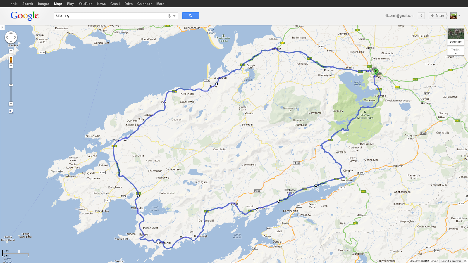
So basically ni map Ring of Kerry (line biru). Skali baca, bunyi macam Lord of the Ring lak keh keh. Daripada Limerick, kitorang sampai Killarney dulu. Lepas stop isi petrol, tarik nafas dalam2, kitorang mulakan dengan bacaan Bismillah. Aku jadi leader, kete Adi/Nazri follow kat blkg sebab aku yg susun route mana nk lalu dulu. Roughly, kitorang lalu Killarney - Muckross - Derrycunihy (Ladies View) - Molls Gap - Gallavally - Gap of Dunloe -  Killorglin - Portmagee (Cliffs viewing) - Kenmare - Killarney. Memang jauh trip ni, dari pagi sampai ke malam. Tak silap, sampai rumah Anuar kul 11pm kot. Rasa serik pon ada huhu


Muckross House

Dari Killarney, our 1st destination was Muckross Estate. Ia adalah satu kawasan reserved national park yang luas, kat dalam tu jugak ada Muckross House (MH). Actually jarak dalam 5km je, tapi terasa agak lama sebab jalan tak luas dan bengkang bengkok. Dan kitorang park kete kat main road. Pastu naik kereta kuda gi MH haha. 


Kesian gak tengok kuda ni terjelir2 lidah angkut kitorang berenam. Pakcik owner ni pulak asyik duk sebat je. Ada one time tu, kuda tu terberak, bau tak hingat punyaa.. Kesian tul, berat sangat sampai terberak :( Mana taknya, sorang berat 80kg, aku je 70kg wakakaka, acah je. Tp masa tu kitorang gelak je la sebab seat aku n Nazri yg paling dekat ngan bontot kuda LOL. Kena nganjing tak hingat. hehe. 


Baru sampai destinasi.credit: fb Ana Nae

Paling kesian bila kuda tu kena panjat bukit. Takde la cerun sangat tapi konfem penat, rasa nk turun je bagi kuda tu lepas bukit. Tapi memikirkan kitorang habis dekat 180Euro naik kereta kuda punya pasal, belasah je la. Masa ni la nk perasan jadi prince dan princess naik pumpkin carriage :P 


 Ni la rupa Muckross House, built 1843

MH ni cuma big mansion, bukan castle. Dia ada 65 buah bilik. Tapi kalo depa bagi tido free, aku pon tanak. Spooky gila, dah la line tepon takde, outskirt nk mampos. Aku takleh bayang mcm mana punya gelap kalo waktu malam. 


MH ni pernah dibeli oleh Arthur Guinness (tokey arak tu). Then ada American mana ntah yg beli as wedding gift for his daughter, then in 1932, he donated the property to Irish gomen in memory for his daughter yg meninggal dunia. 

Entrance
Photo shooting

 Garden kat MH. credit: tripadvisor


Ladies View

We spend around 2 hours kat MH termasuk jelajah berkereta kuda. Then we continued our journey to Ladies View, somewhere dekat Derrycunihy. By measurement, it's only 11km from Muckross tapi rasa macam lama sangat. So it's the best spot to stop memandangkan anak aku takleh duk diam lama2 dlm kete. Kat situ pon ada cafe dan toilet of course.


Ladies View, LV (cewah, LV youu) ni diberi nama sempena lawatan personal assistant atau PA (atau bahasa istana mat saleh panggil Ladies-in-waiting) kepada Queen Victoria yg datang lawat sini tahun 1861. Dia suka view ni, so jadi la Ladies View. suka2 je kan? Nanti aku cari port lain lak, jadi Pok Nik's View (PV)

 Natural wild life yg berkeliaran kat area sini. Tak liar, tapi tak juga jinak 


Sempat melakukan sedikit vandalism utk semadikan nama kitorang kat LV 

Beautiful view, indeed. Lebih cantik bila ada nama kitorang terukir kat situ muahaha

Center of LVcredit: fb Ana Nae
Tasik kat atas tu adalah "Upper Lake of Killarney National Park"

Sepanjang perjalanan Ring of Kerry ni, banyak mat saleh yg cycling. Rajin betul panjat bukit ngan basikal je. Kagum aku tengok semangat adventurous diorang. Entah2 dlm hutan tu ada yg jungle trekking. Tak heran bila aku pernah jumpa mat saleh yg kayuh basikal kat East-West Highway (Jeli - Grik). Tabik sama diorang


Molls Gap

Molls Gap


Dah puas rehat, kitorang sambung lak our drive. From here kitorang drive toward Molls Gap. Dekat sejam gak. Takde apa yg menarik pon. Sekadar bukit berbatu2. Aku pon tatau nape aku posing kat sini. Jakun kot. Lepas Molls Gap, we turned right towards Gap of Dunloe (GoD). This is where the challenge begun.


Gallavally

Tapi sebelum sampai GoD, kena lalu Gallavally dulu, basically tempat ni dah 'start' indicate yg kitorang sedang masuk ke kawasan bukit berbatu. I never seen structure mcm ni. Pelik dan unik. Jalan makin lama makin sempit, aku rasa semua dlm kete dah cuak. "Betul ke Nik ni, mcm sesat je" haha

Gallavally

End of Part I.....

Part III (Kerry Cliffs at Portmagee)